The first warning didn’t arrive as a headline or a blaring alert. It came as a feeling—an unease that settled into the bones of people who watch the sky for a living. In quiet forecast offices, in satellite control rooms, in university labs humming with old coffee and new data, meteorologists stared at the charts and recognized something that made their hands pause over the keyboard: the jet stream, that roaring river of wind high above our heads, looked ready to bend, buckle, and realign far earlier than it should this winter. January, they whispered to each other—January might not behave like January at all.
A River in the Sky, Suddenly Restless
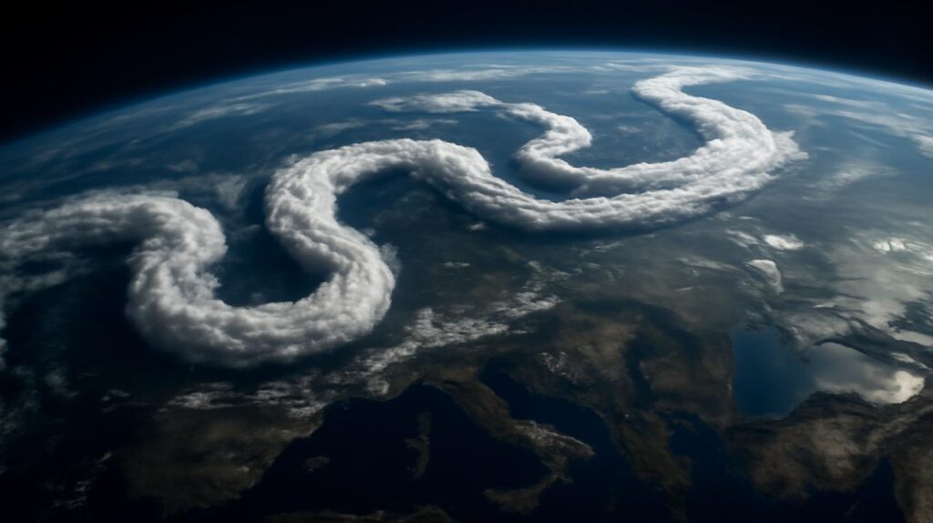
Picture the jet stream as an invisible highway, racing around the Northern Hemisphere about eight to twelve kilometers above your head. It’s a narrow band of furious wind—sometimes faster than a commercial jet—that roughly separates colder polar air from the milder air closer to the equator. For decades, this high-altitude current has been the quiet architect of our seasons, guiding storms, steering cold snaps, and framing heatwaves. We live under its decisions every single day, most of us never knowing its name.
But this year, as December slid toward January, computer models began to sketch a different story. The jet stream that usually hunkers down into a familiar winter pattern looked restless, ready to shift north and south in exaggerated loops, to swerve into new positions weeks earlier than historical averages. It was as if the river in the sky had grown impatient with its usual course.
Meteorologists watched the charts bloom with wild colors—the blues of deep cold plunging south, the red plumes of strange warmth surging north, the contours of pressure systems stretching into odd, meandering shapes. Usually these kinds of kinks and realignments become the main act later in winter, sometimes sparked by events like sudden stratospheric warmings. But this time, the atmosphere seemed to be jumping the queue.
The result? A rising buzz of anxiety among the people whose reputations live and die by the forecast. Because when the jet stream moves in unusual ways, the weather on the ground can swing from eerie calm to outright chaos.
How a Crooked Jet Stream Warps Our Weather
The jet stream’s position is like the track layout for a train system: change the track, and every destination changes with it. When the jet stream is strong and relatively straight, storms tend to move along briskly, cold spells and warm spells rotate in a steady rhythm, and seasonal expectations mostly hold true. But when it weakens and starts to wobble—forming long, sinuous waves that plunge south and then curl high north—things start to get strange.
Imagine January days where one region is locked in brutal, bone-deep cold while a few thousand kilometers away people are hiking in light jackets under mild, almost springlike skies. That’s what happens when one of those jet-stream waves dips down, dragging Arctic air behind it, while another ridge arches north, inviting subtropical warmth to visit places that aren’t ready for it.
In the glow of forecast screens, meteorologists see the fingerprints of this coming January pattern everywhere: blocked high-pressure systems that could trap stagnant air and smog over cities; conveyor belts of moisture that may dump relentless rain or heavy snow; rapid switches from warm to cold that challenge infrastructure designed for something gentler and more predictable.
One forecaster in a coastal city scrolls through ensemble models and pictures a river swelling against its banks during an unseasonable rainstorm, the snowpack in nearby mountains too thin to act as a natural reservoir. Another looks at an upcoming cold plunge and thinks of brittle power lines, stressed grids, and the long human memory of past winter blackouts. This is where the jet stream’s geometry stops being an abstract graphic and turns into flooded basements, icy highways, failed crops, and quiet worries at kitchen tables.
The Subtle Art of Being Wrong at the Worst Time
Forecasting is always a dance with uncertainty, but early jet stream realignment raises the stakes. Seasonal outlooks—those widely shared maps showing warmer- or colder-than-average predictions, wetter or drier odds—are built on decades of data and patterns. They assume a rough sequence to how the atmosphere tends to behave as Northern Hemisphere winter settles in. When that sequence changes, it’s like moving the furniture in a dark room. Suddenly, every step risks a bruise.
Climate scientists, too, face a sharpened edge of doubt. Many climate models have captured the broad strokes of what a warming world does to the jet stream: the Arctic heats faster than mid-latitudes, eroding the temperature contrast that helps power that high-speed current. A weaker contrast can lead to a wobblier, slower jet stream, which in turn can increase the chance of persistent, extreme weather. But the timing and flavor of these changes—how often, how early, how dramatically the jet wants to twist and shift each winter—are not yet well-refined down to the level of months or regions.
So when January starts looking like March in one place and late November in another, some of our best long-range expectations can suddenly feel outdated. This is where “climate miscalculation” comes in—not as a grand failure of understanding, but as a thousand small mismatches between what we planned for and what the atmosphere decides to do.
When Maps and Lives Collide
For most of us, atmospheric dynamics remain an abstract concept until they land in the street outside the house. The concern this year is not just that the jet stream will realign early, but that it will set off a chain of events that ripple through farms, cities, and fragile systems already under stress.
Consider the farmer who looks at a seasonal outlook and decides when to plant winter wheat, or whether to invest in a new irrigation system for the coming year. If the jet stream brings repeated warm spells followed by sharp freezes, crops can be tricked into early growth and then burned back by sudden cold, leaving fields patchy and vulnerable. Orchards, especially, live or die by a few key temperature swings.
In urban neighborhoods, an early-shifting jet stream might mean bouts of heavy rain over frozen ground—where the water can’t easily soak in—leading to flash flooding in streets that usually only see such scenes in spring. Or it could mean prolonged inversions: layers of warmer air trapping colder, polluted air near the surface, turning an ordinary winter week into a health hazard for people with asthma or heart disease.
Emergency managers, already stretched thin by an era of “unprecedented” events that seem to arrive every season, must grapple with forecasts that hint at extremes but can’t yet pin down exact locations or timing. Do they pre-position sandbags and portable generators? Do they plan for snow or rain, ice storms or early thaws? The answers ride on the jet stream’s mood.
Behind every atmospheric map are ordinary lives recalibrating. A parent checks the extended forecast, wondering whether to stock up on extra food or just more hot cocoa. A small-town mayor thinks about the budget line for road salt, about overtime for snowplow crews… or maybe flood pumps instead. Each decision is a bet placed on the future, a quiet test of how much we truly understand the sky above us.
A Subtle Shift, a Global Story
What makes this early realignment especially unnerving is its scale. The jet stream doesn’t respect borders. When it dips and surges, it links the fate of distant places in a way that can feel uncanny. A blocked pattern over the North Atlantic might mean relentless rain for one country and bone-dry, cloudless high pressure for another. A wayward jet over the Pacific can amplify storms hitting the west coasts of continents thousands of kilometers apart.
Even if your local weather ends up feeling mostly “normal,” the knock-on effects of someone else’s extremes can reach you. Crop failures in one region ripple through global food prices. Storm-damaged infrastructure in another can disturb trade, supply chains, and energy markets. What appears on your weather app as a mild winter might actually be the quiet downstream result of chaos upstream.
To many meteorologists, this interconnectedness is what keeps them up at night. They can see how an early, unusual jet stream pattern stacks on top of other stressors: warmer oceans feeding stronger storms, disappearing snow cover changing how much sunlight the land reflects, parched soils or saturated floodplains altering how each new weather system behaves. The atmosphere, land, and sea are caught in a feedback loop, and every odd winter season like this January is both a symptom and a new input into that looping system.
Reading the River: What the Data Is Whispering
In dimly lit forecast offices, the language of concern is color and contour. Maps loaded on screens show wind speeds at high altitudes—streaks of purple and red tracing out the roaring heart of the jet stream. Overlaid on that are temperature anomalies, pressure levels, humidity fields, and an arcane alphabet soup of indexes known mostly to specialists.
Over the past few decades, these records have been quietly accumulating a story: winters are changing. The Arctic has been warming more than twice as fast as the global average, and that warming tends to weaken the temperature gradient between the poles and the mid-latitudes—the very gradient that helps drive the jet stream. Some research suggests this can lead to a lazier, more meandering jet that stalls weather patterns. Not all scientists agree on the exact mechanisms or the strength of these connections, but few doubt that we’re drifting into atmospheric territory our grandparents rarely saw.
To make sense of it, forecasters juggle two timescales at once. On one hand, there’s the immediate concern: what will this unusual early-January pattern do over the next 10 to 30 days? On the other, the long arc of climate: what does this episode say about the kind of winters we’re heading toward in the coming decades?
Ironically, better data can sometimes sharpen our anxiety. Where once a strange winter might have been written off as a fluke, now it’s cross-checked against satellite imagery, reanalysis datasets, and the output of countless climate simulations. When the same themes keep popping up—early disruptions, intensified extremes, awkward timing—that “fluke” begins to look more like a trend.
Numbers That Touch the Ground
For those planning ahead, even rough guidance is better than none. While meteorologists avoid dramatic certainties, they do sketch out scenarios and probabilities. To visualize the potential impacts of an unusually early jet stream realignment this January, imagine something like this simplified picture:
| Region | Likely Jet Stream Influence | Possible Weather Outcomes |
|---|---|---|
| Northern Continental Areas | Deep southward dips of cold air | Intense cold snaps, heavy snow, ice storms, higher energy demand |
| Mid-Latitude Cities | Rapid shifts between ridges and troughs | Swinging temperatures, rain-on-snow flooding, freeze–thaw damage to roads |
| Coastal Regions | Storm tracks shifting north or south | Stronger windstorms, coastal flooding, or unusually calm, dry spells |
| Agricultural Zones | Irregular warm spells and sudden cooling | Crop stress, early budding followed by frost, soil moisture extremes |
This isn’t a guarantee; it’s a sketch—a way of saying that the atmosphere’s choices upstairs can narrow or broaden the range of local stories playing out on the ground.
Living with a Less Predictable Sky
What do you do with the knowledge that the jet stream might be about to redraw the map of January?
Some answers are practical. Check forecasts more often, especially during transition periods when temperatures are jumping or storms are lining up offshore. Pay attention to local advisories about flooding, ice, or high winds. The atmosphere may be more erratic, but our tools for tracking it—high-resolution models, real-time radar, location-aware alerts—are better than they’ve ever been.
Other answers are quieter and more personal. Notice how your own sense of the seasons has shifted. Maybe you recall childhood winters when snow cover was a steady backdrop, compared to today’s on-and-off, slushy uncertainty. Maybe you live farther south and have seen “winter” shrink to a few cool weeks bracketed by extended warmth. These lived impressions are not just nostalgia—they’re data, too, woven into the larger scientific story.
On a community level, the challenge is to build flexibility into systems that were designed for a more stable climate. Cities may need to adapt drainage for heavier downpours even in months once considered “dry.” Power grids must survive both heatwaves and cold outbreaks that are sharper and differently timed than before. Farmers are experimenting with new crop varieties, planting dates, and soil practices that can better ride out these swings.
The key is not to expect precision where it can’t exist, but to ask better questions: If this winter is 20 percent more likely to bring a flooding rain or an ice storm, what changes now could save trouble later? If the jet stream is turning into a more fickle neighbor, where do we need backup plans?
The Emotional Weather of a Changing Climate
There’s a psychological weight that comes with phrases like “extreme weather chaos” and “climate miscalculation.” It can be tempting to tune out, to retreat into denial or numbness. But there’s another way to meet this moment: with a kind of focused curiosity.
Stand outside on a day when the weather feels “wrong” for the time of year. Maybe the air is too warm and carries the damp smell of soil instead of the crisp bite of frost. Maybe it’s the opposite: a sudden, shocking chill under a bright sun. Notice the birds, the trees, the way your breath moves in your chest. This isn’t just strange weather; it’s the lived edge of a planetary experiment we didn’t mean to start.
The jet stream’s early realignment this January is one chapter in that unfolding story. It’s not proof of doom, nor is it a passing curiosity. It’s a signal—subtle, technical, and yet profoundly human in its consequences—that the old calendars of expectation are fraying. The more honestly we look at it, the better our chances of writing the next chapters with care rather than shock.
In the end, those meteorologists, hunched over their screens, are not just reading numbers. They’re trying to give us a few days’ or weeks’ head start on whatever the river in the sky decides to do. They are, in their own way, storytellers too—translating the restless language of wind and temperature into something we can act on.
This January, as the jet stream flexes and bends ahead of schedule, their message is clear: pay attention. The sky is changing shape faster than we thought, and the decisions we make down here will determine how well we weather what comes next.
FAQ
What exactly is the jet stream?
The jet stream is a narrow band of very strong winds high in the atmosphere, typically between 8–12 kilometers above the surface. It forms where cold polar air meets warmer air to the south, and it helps steer storms and shape temperature patterns across entire continents.
Why is an early realignment in January such a concern?
January usually has more stable winter patterns. An unusually early realignment suggests the jet stream is shifting into a more wavy, unstable configuration sooner than expected, which can increase the risk of extreme cold snaps, unusual warmth, heavy precipitation, or prolonged stagnant weather conditions.
Does this prove that climate change is altering the jet stream?
It adds to a growing body of evidence, but no single event “proves” anything on its own. Many studies suggest that Arctic warming and other climate shifts are affecting the jet stream’s strength and path. Anomalies like this early realignment are consistent with those concerns, even if the exact mechanisms are still being researched.
How might this affect my daily life?
Impacts vary by location, but you could see sharper temperature swings, more intense storms, unexpected thaw–freeze cycles, or periods of unusual warmth or cold. These shifts can influence travel safety, energy bills, health (especially for vulnerable groups), and local flooding or snow conditions.
Can forecasts still be trusted if patterns are changing?
Yes—short-range forecasts (a few days out) remain very reliable and have improved dramatically in recent decades. What’s more uncertain is the timing and character of seasonal patterns weeks to months ahead. It’s wise to use forecasts regularly, stay alert to updates, and treat longer-range outlooks as guidance rather than guarantees.
Is there anything individuals can do to prepare?
On a practical level, keep basic supplies for storms or power outages, maintain your home’s drainage and insulation, and stay informed through trusted local weather sources. On a broader level, supporting efforts to reduce greenhouse gas emissions and to adapt infrastructure to more extreme weather helps reduce long-term risks for everyone.
Will future winters keep getting more erratic?
Most climate projections suggest that as the planet continues to warm, many regions will face more frequent and intense weather extremes, including in winter. That doesn’t mean every year will be wilder than the last, but the odds of unusual and disruptive patterns—like early jet stream realignments—are expected to increase over time.


