The sky above you this February might look ordinary: a soft gray lid of cloud, a thin winter sun, maybe the glint of ice on parked cars. But far higher than the tallest jet, more than twenty miles above the ground, something strange is happening—something that could twist the rest of winter into a new shape. It’s silent, invisible, and utterly colossal: a rare early-season stratospheric warming event, the kind of atmospheric drama that turns weather models on their heads and leaves even seasoned experts arguing over how worried the public should be.
The Quiet Drama 30 Miles Above Your Head
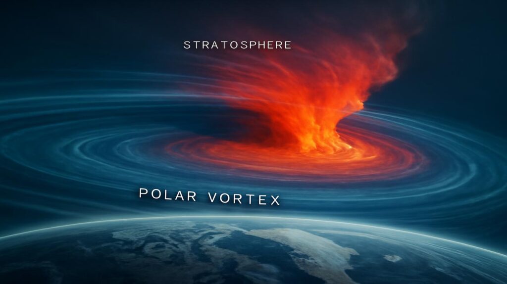
To understand why scientists are suddenly animated about the upper atmosphere, imagine the atmosphere as a layered orchestra. Near the ground, in the troposphere, we live among the most familiar instruments—storms, rain, snow, wind. This is the noisy front row. But above that, from about 10 to 30 miles up, lies the stratosphere: a quieter balcony where the air is thin, dry, and usually calmly spinning around the pole like a massive, icy carousel.
That spinning system is called the polar vortex. It’s not some single storm, but a giant ring of screaming-fast winds encircling the Arctic, trapping the coldest air near the pole. In a normal winter, it hums along like a well-oiled machine, helping keep the freezer door of the far north mostly closed.
But this February, the machine has started to grind and wobble. Temperatures high in the stratosphere have suddenly surged by tens of degrees in just a few days—a phenomenon known as a stratospheric sudden warming, or SSW. It’s as if someone turned a blowtorch on the Arctic sky.
Down here on the ground, we don’t feel that heat directly. Instead, the impact travels downward in slow motion, like a barely perceptible crack spreading through a frozen lake. Over the course of days to weeks, those disrupted winds aloft can reach the weather we live in, potentially causing traffic jams in the jet stream, rerouting storm tracks, and rearranging where the most brutal cold ends up.
The Science of an Invisible Earthquake
Picture standing on a quiet winter field at dusk. The snow squeaks under your boots. Overhead, the sky is clear and still. What you cannot sense is the chaos brewing dozens of kilometers above, where waves of air—stirred by mountains, storms, and land–sea contrasts—rise from the lower atmosphere and slam into the stratosphere.
Under normal circumstances, the polar vortex shrugs off this wave energy, staying mostly intact. But every so often, those waves arrive in just the right rhythm and strength to punch huge holes in that spinning ring of winds. When that happens, the icy vortex can weaken, split into multiple lobes, or shift off the pole, sending lobes of frigid air wandering south like lumbering giants that have lost their footing.
In this early-season episode, the warming has come sooner and more abruptly than many forecasters expected. Air over the polar stratosphere has surged by 30–50°C (though still well below freezing), and wind speeds that were racing west-to-east have slowed dramatically, even reversing in some layers. In atmospheric science, that reversal is a siren: a key sign that the vortex is collapsing.
It all unfolds in silence. No flash. No roar. Yet the atmosphere’s “spine” has effectively suffered an invisible earthquake, and everything below may feel the aftershocks.
Models, Maps, and a Forecast Tug-of-War
In dimly lit forecast offices, glowing screens are suddenly crowded with swirling colors and looping lines. Meteorologists pore over ensemble models—dozens of simulated futures—watching the polar vortex contort and lose coherence. Some of those simulations show intense cold spilling into North America and Europe weeks from now. Others suggest only a muted impact, with the worst of the disruption confined closer to the poles.
The irony is that a warming event high above can sometimes herald deeply cold weather below. When the vortex breaks down, the jet stream can buckle and slump, sending arcs of polar air plunging southward and holding them there. Cities that have breezed through a mild early winter can suddenly find themselves staring down a late-season freeze, heavy snow, or a barrage of icy storms.
Yet not every stratospheric warming delivers blockbuster cold. Some fizzle before they fully couple with the troposphere. Sometimes the vortex distorts but recovers, leaving forecasters to explain why the much-hyped cold stayed locked up in northern Canada or Siberia. This uncertainty is one of the biggest frustrations for both scientists and the public.
To get a sense of how complex the signals can be, it helps to compare key elements for different SSW events:
| Feature | Typical Winter | Classic Strong SSW | This February’s Event* |
|---|---|---|---|
| Polar vortex strength | Stable, strong | Severely weakened or split | Rapid weakening, signs of splitting |
| Stratospheric temperature change | Gradual, modest | +30–50°C in ~1–2 weeks | On track for +30–40°C |
| Jet stream pattern | Fairly zonal (west–east) | Highly wavy, blocked | Modeling shows increased waviness |
| Typical surface impacts | Seasonal cold, variable storms | Heightened risk of cold outbreaks & snow | Elevated risk, but highly uncertain |
| *Based on current observational and model data; subject to change. | |||
The table offers only a snapshot of an evolving drama. As new data pours in and models update, some scenarios vanish, others grow more likely. This constant reshuffling is why you may see wildly different outlooks depending on which expert you follow and which day you check the forecast.
The Expert Divide: Alarm, Caution, and Communication
Among atmospheric scientists and forecasters, stratospheric warmings don’t just spark technical debates; they stir deep questions about risk, responsibility, and how we talk about uncertainty. In conference calls and email threads, the discussion often turns from maps to messaging: What do we tell people?
On one side are those who argue that these events demand early, forthright warnings. They point to past winters when an SSW preceded crippling snowstorms, infrastructure failures, and deadly cold. The polar vortex disruption of early 2021, for instance, helped set the stage for the catastrophic freeze in Texas. Power grids buckled. Millions lost heat. The cost in lives and livelihoods was enormous. If a stratospheric event raises the odds of such extremes, they say, the public deserves to know as early as possible.
On the other side are experts wary of overhyping. They remember SSWs that never quite translated into the expected surface impacts, when social media filled with ominous vortex headlines but most communities saw only modest changes in their weather. Crying wolf too often, they argue, can make people tune out future warnings—or dismiss all talk of the stratosphere as overblown science theater.
Threaded through the debate is a more subtle question: how do you explain something so abstract? You can show a satellite loop of a hurricane, a radar sweep of an incoming squall line. But a swirl of wind anomalies at 10 hPa pressure? A line graph of wind reversal at 60°N? These are hard sells for anyone outside the weather world.
Communication experts urge a middle path: speak plainly about elevated risks without pretending to know exactly where the hammer will fall. Emphasize that this is one powerful factor among many—El Niño or La Niña, ocean temperatures, snow cover, even soil moisture—that together shape the season’s mood. In other words: this February’s stratospheric fireworks don’t script the future, but they are rewriting several key pages.
What It Could Mean for Your Winter
If you step outside on a crisp February morning and the cold bites just a little deeper, it’s tempting to pin every shiver on what’s happening overhead. But the pathway from stratospheric warming to your front yard is long, tangled, and not guaranteed.
Here’s what forecasters will be watching over the next few weeks:
- Does the warming propagate downward? If the changes in wind and temperature aloft begin to echo lower and lower, into the mid-stratosphere and eventually the upper troposphere, it’s a sign that the vortex disruption is coupling with the layers where our weather lives.
- Where do the high-pressure “blocks” set up? Large, stubborn domes of high pressure can park over Greenland, the North Atlantic, or Siberia, diverting the jet stream. Their exact placement can decide whether cold dumps into the eastern United States, western Europe, or stays bottled up over interior Asia.
- Does the jet stream become more meridional? A more north–south (rather than west–east) pattern often supports dramatic temperature contrasts and repeated storm systems tracking along those sharp boundaries.
In a best-case scenario, the vortex stumbles but doesn’t collapse entirely. You might see a few notable cold shots, some sharp swings in temperature, and an uptick in late-season snow chances in certain areas, but nothing that rewrites the history books. A kind of atmospheric wobble, not a full-on spill.
In a more severe scenario, the vortex splits or displaces dramatically, and a lobe of Arctic air locks in over a mid-latitude region for weeks. Suddenly, heating bills soar. Roads glaze over. Cities that thought winter was easing into spring find themselves back under deep snow, schools closed, and pipes groaning in the crawlspaces of older homes.
Which path will this February’s event follow? The honest answer is: no one knows yet. The atmosphere guards its secrets carefully. But the range of plausible futures has shifted. The dice for late-winter extremes have been subtly, but noticeably, loaded.
Should You Worry—or Just Pay Attention?
The phrase “divide experts over how much the public should worry” sounds almost like a headline crafted to stir anxiety. But underneath it lies a genuinely tricky question: what is the right emotional response to something like a stratospheric warming event?
Worry, on its own, doesn’t help you much. The polar vortex won’t weaken faster because you checked the forecast twelve times today. But attention—the calm, practical kind—can. There’s a quiet power in simply knowing that the atmosphere is entering a more volatile phase and letting that knowledge nudge a few of your choices.
Maybe you delay that long road trip by a day or two if a potential snowstorm looms at the edge of the forecast. Maybe you make sure the drafty window in the guest room is finally sealed. Perhaps you talk with an elderly neighbor about what they’d do in case of a prolonged cold snap or a power outage. If you work in a city’s emergency management office, this is absolutely the time to dust off contingency plans for cold extremes, energy demand spikes, and icy roads.
None of this requires panic. It asks only that you move from a mindset of “winter’s almost over” to one of “winter might have a second act.” Because if this stratospheric event does meaningfully alter the jet stream, that second act could be sharp and memorable, even if brief.
The good news is that we are far better at tracking and modeling these events than we were a generation ago. While uncertainties remain large, the very fact that we can see the vortex wobbling weeks in advance is a kind of quiet triumph for science. The goal is to turn that foresight into steadier preparation, not spiking fear.
Listening to a Sky You Can’t See
As daylight begins to stretch a little longer into evenings and the first drip of meltwater ticks down from eaves, it is tempting to declare winter finished. Seed catalogs wait on kitchen tables. The imagination leaps forward to birdsong and green shoots.
Yet high above those lengthening days, the atmosphere is in revolution. Invisible thermal shockwaves are rippling through the stratosphere, unspooling a story that will only be fully written as March approaches. Whether you end up feeling it as a piercing wind under your collar, as a last big snowstorm, or only as a slightly higher heating bill, this February’s rare stratospheric warming is a reminder that the seasons are not smooth arcs but improvisations.
Modern nature storytelling often celebrates what we can see: a fox crossing fresh snow, geese cleaving gray sky, the slow turning of leaves. But there is also a kind of wildness in what we cannot witness directly—rivers of air twisting above the planet, invisible heat blossoming in the thin air of the stratosphere, the way a disturbance thirty miles high can make a pane of glass shiver in your living room weeks later.
You do not need to memorize the intricacies of wave–mean flow interactions or memorize pressure levels to appreciate this. It is enough to know that, right now, far beyond the reach of any storm cloud, the planet’s atmosphere is having one of its rare, dramatic arguments with itself. The outcome of that argument may shape how you remember this winter: as a gentle glide into spring, or as the year winter doubled back for one last, defiant breath.
Frequently Asked Questions
What is a stratospheric sudden warming (SSW)?
A stratospheric sudden warming is a rapid increase in temperature in the polar stratosphere—often 30–50°C in a week or two—accompanied by a disruption or reversal of the strong winds that circle the pole. It can weaken or split the polar vortex and sometimes leads to changes in weather patterns closer to the surface weeks later.
Does a stratospheric warming always mean extreme cold is coming?
No. While an SSW increases the odds of cold outbreaks and altered storm tracks in the following weeks, it’s not a guarantee. Some events have strong, prolonged impacts at the surface; others remain mostly confined to higher levels of the atmosphere or affect regions far from where people expected.
Why is this February’s event considered unusual?
It is both early and strong compared with many past events. The rapid warming and signs of a significantly weakened polar vortex have arrived earlier in the late-winter season than typical, which can catch forecasters and seasonal outlooks off guard and force a reevaluation of late-winter and early-spring expectations.
Should the average person be worried about this?
Concern should focus more on awareness than fear. A rare SSW is a signal that the atmosphere is entering a more unstable, high-variability phase. It’s wise to pay closer attention to medium-range forecasts, prepare for the possibility of late-season cold or snow, and ensure you’re ready for potential disruptions—but there’s no need for panic.
How long do the effects of a stratospheric warming last?
The direct warming in the stratosphere can unfold over a week or two, but its influence on the troposphere and surface weather can last several weeks, sometimes up to a couple of months. The strongest surface impacts, when they occur, often appear 1–3 weeks after the peak of the event.
Is climate change making these events more common?
Research is ongoing, and there is no clear consensus yet. Some studies suggest that changes in Arctic sea ice, snow cover, and overall warming might be influencing the frequency or character of SSWs, but the signal is complex and intertwined with natural variability. Scientists are still working to tease out long-term trends from short-term fluctuations.
What can I practically do in response to this event?
Monitor updated forecasts over the next few weeks, especially if you live in regions prone to winter extremes. Make sure your home is prepared for potential cold snaps—check insulation, have backup heat sources if possible, and ensure you have basic supplies. If you manage infrastructure, transportation, or emergency services, this is a good time to revisit cold-weather contingency plans and coordinate with local agencies.


